Asheville, NC
There's no place I've found that's as good for road riding as Asheville, North Carolina. My experience isn't all that broad, but I did spend a week in Mallorca, Spain a few years back. While it was tremendously beautiful, mountainous, and fun, it still wasn't as good as the mountains in Western North Carolina.
This year's trip was my sixth trip to Asheville, and this year we had a full house. Friends came in from central New York, West Virginia, Canada, Pennsylvania, and Texas. We never did use the hot tub in the garage of the rental place, but we definitely used the garage. So many nice bikes in such little space!

I personally put in 290 miles and a little over 35,000 feet of climbing in four days of riding. That included sitting out two days resting due to a head cold I came down with the night we arrived in town. In the crisp, clear mountain air my cold stayed light and didn't bother my breathing much, so I was able to pour on the steam on most of the rides and felt great. Unfortunately, Sue developed left knee pain on the first full day of riding, sat out the next day, got an emergency visit with a local physical therapist, but still could not ride. She bagged the vacation and flew home on Wednesday. She worked so hard all winter inside on rollers and outside in dark and foul weather, with the racing season in mind, but especially planning for this Asheville trip. All that work for so much disappointment was a real killer.
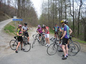
We did what has become known as the "Old Fort-Hickory Nut Gorge-Lake Lure-Shriners' Hill-Broken Road" ride, which is a staple route for a trip to Asheville. The local bike club published a ride guide that includes an "Old Fort Hickory Nut Gorge" ride and we expanded on both the length of the route and the name. It's a ride southeast of Asheville, where the climbs are shorter and generally more shallow, but with a great variety of slopes, turns, pavement, and fantastic views.
It departs at a convenience store on Cane Creek Rd, just a couple miles away from the Cane Creek factory. We've never tried to get a tour, but we usually honk "hello" on the way past. From there, we hit the first climb over Hickory Nut gap, a mile or so long and fairly shallow, made for big guys with big gears. Very fast uphill. The descent into Bat Cave follows, a five or six mile working, twisting downhill. If you work hard you go really fast, or you can coast for a more gentle ride down. I ended up putting out more wattage on the way down in spots than I did on the way up the other side. Whew!
We passed the scenic Chimney Rock tourist site. We've never been to the lookout at the top since bikes aren't allowed up the twisting climb. Only pedestrians and motorists. They assume that cyclists will kill themselves on the way down, I suppose. Too bad really, as it would be a great climb with a nice reward at the top. We wind around Lake Lure, and the road there twists and weaves and dips and bobs like a prize fighter. We poured on the gas there, and turned the road into a roller coaster ride we had control over. Fantastic.
Leaving Lake Lure, we headed towards Old Fort. A couple of steep leg-breaking climbs softened us up before the Shriners' Hill, so named because one is inclined to weave up the steep sections like the motorcycle-riding octogenarians one sees in parades. A steep gravel road followed immediately, then a nice descent, and a stop for refueling in town.
From there, we went off-roading. The star section of the route is a long, shallow climb on an abandoned road, old route 70, I believe. It's barracaded at both ends, concrete in some sections, blacktop in others, all of it cracked and broken, with occasional sticks, dirt piles, leaves, and other natural rubbish scattered about. It would be great on cross bikes, but it's pretty darn fun on road bikes too, as long as you didn't bring your best lightweight carbon wheels. We regrouped at the top, then set off for Black Mountain, just a mile down the road.
The next turn put us on route 9 for the last climb of the day, over Lackey Gap. It's a moderate hill, fast, sweeping turns, and about 10 minutes long at my top pace. Even after all the miles before, I was able to stick my wattage between 290 and 325 (good for the shape I'm in right now) and felt like I was flying up the climb.
A descent and many rolling hills follow on the miles back to the cars. It's quite a ways, and with no major climbs left, one can fall into the idea that the ride should be over and then start a death march back. I had some gas left in the tank and on a couple sections of rolling sprinters' hills pushed hard with my friend and big engine, Drew, to hammer along over them.
By the end, we'd put in 78 miles with about 10K feet of climbing, and I felt great and knew that I'd laid down some great training, putting in several long intervals of high-wattage effort punctuated at the end with several short bursts of very high power over the bumps at the end.
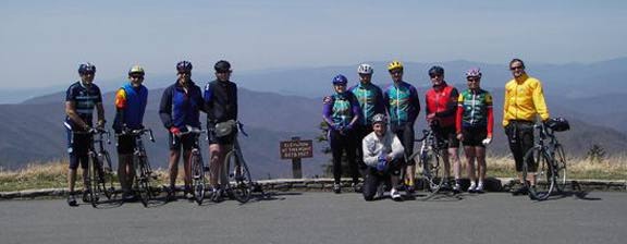
For the final ride, the skies were clear and the temperatures near record warmth for our ascent up Mount Mitchell. We left from the house near Weaverville, and our first effort was climbing the steep Ox Creek Road up to the Blue Ridge Parkway. From there, it's miles and miles of gentle climbing with several tunnels, and marvelous views out over the valleys. I had waited to make sure everyone took the right turn off of Ox Creek, so I started the Blue Ridge climb a few minutes behind the leaders in our group. With the great motivation of having people up the road to try to catch, I just set my legs to turning out 225-250 watts, knowing that effort was below my LT and I could hold it for a long time. At last, the left turn onto the main park road appeared, marking about five more miles left, including some very steep sections. About 25 minutes and some very heavy breathing and aching legs later, I was in the parking lot at the top sitting on the grass, munching some food, relaxing and stretching. Riders drifted in to cheers from others of us who'd already reached the top. We lounged about soaking up the sunshine in the cool breeze, refilled our bottles, and eventually decided it was time to head down.
Getting off the mountain was a bit rough, with high winds on certain steep sections threatening to pull the wheels out from underneath us. Once we reached the parkway though, it was smooth sailing from there. There's actually a couple miles of climbing early on the way back, but then it's all downhill once you cross over the top of the ridge. A large group of us screamed down the parkway, putting in huge efforts at the front of the paceline, then swinging off to give the next person the thrill of pouring on the power and yanking us downhill at top speed. We skimmed over some potholes and flew through the dark tunnels, averaging 30-40 mph for most of the descent. Bleary-eyed from wind and effort at the bottom, we all regrouped and excitedly told tales of our own experiences on the way down.
Finally, we dropped like stones down Ox Creek, leaning over through hairpins and laughing along with the pull of gravity we'd been cursing just a couple hours before. After a bit of a death march back through town to the house, bodies soaked up liquids, crammed down food, and dropped into lounge chairs for some well-deserved rest.
As always, by the end of the trip, everyone was saying, "I can't wait to do this again next year!" One of these years I suppose we won't be able to make the trip for one reason or another, but when it happens, I'm betting it just won't seem like spring without beating ourselves up in the Blue Ridge Mountains of Asheville, NC.
Thanks to Bill Legere and Amy Kneale for the photos!
posted by Tim Bingham @ 8:55 AM
0 comments
![]()

0 Comments:
Post a Comment
<< Home